


23-02-16 Cavalière mimosas2

lygi
User
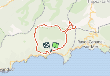

Length
14.7 km

Max alt
475 m

Uphill gradient
580 m
Km-Effort
22 km

Min alt
2 m

Downhill gradient
580 m
Boucle
Yes
Creation date :
2024-02-07 17:27:06.016
Updated on :
2024-02-07 17:27:15.12

FREE GPS app for hiking
 SityTrail
IGN / Geographical institutes
SityTrail Plus
The world is yours!
About
Trail of 14.7 km to be discovered at Provence-Alpes-Côte d'Azur, Var, Le Lavandou. This trail is proposed by lygi.


Positioning
Country:
France
Region :
Provence-Alpes-Côte d'Azur
Department/Province :
Var
Municipality :
Le Lavandou
Location:
Unknown
Start:(Dec)
Start:(UTM)
290696 ; 4780972 (32T) N.
Comments